The Sanders Family Travels Abroad for a Year

Good to have you along for our year long adventures in Ireland and other countries. We are working, playing, and schooling amongst our neighbors in Carna, Ireland.

Please use control + to enlarge the blog, the photos look much better this way. As of March 2011, google has improved the presentation of the blog, the photos show much better now.

Carna is along the west coast on Ireland, a little over an hour's drive from Gallway. It is a pretty rural area, and it is rugged and beautiful, physically and culturally.

We will keep you updated with our life, as we settle into a coastal home and integrate into the community. Greg is working in a Family Practice clinic, mentored by Gerard Hooke, whom Greg worked with a few years ago, for many years, in Arlington, Washington state. Gerard and his wife Amanda have settled into this area a few years ago, and are beloved by the community. The clinic was started by Michael Casey, who worked here solo for many years. He now has 3 clinics in Galway county, where he shares his time.

Our 3 children are in the local schools,where the classes are taught in the Irish language, with some English as well. We are exploring Ireland, on weekend drives. Also, periodically we are hopping over to the mainland Europe, for longer adventures.


Saturday, July 30, 2011

Achill Island

Between Leenene and Cregganbaun

Achill Island, near Dooagh
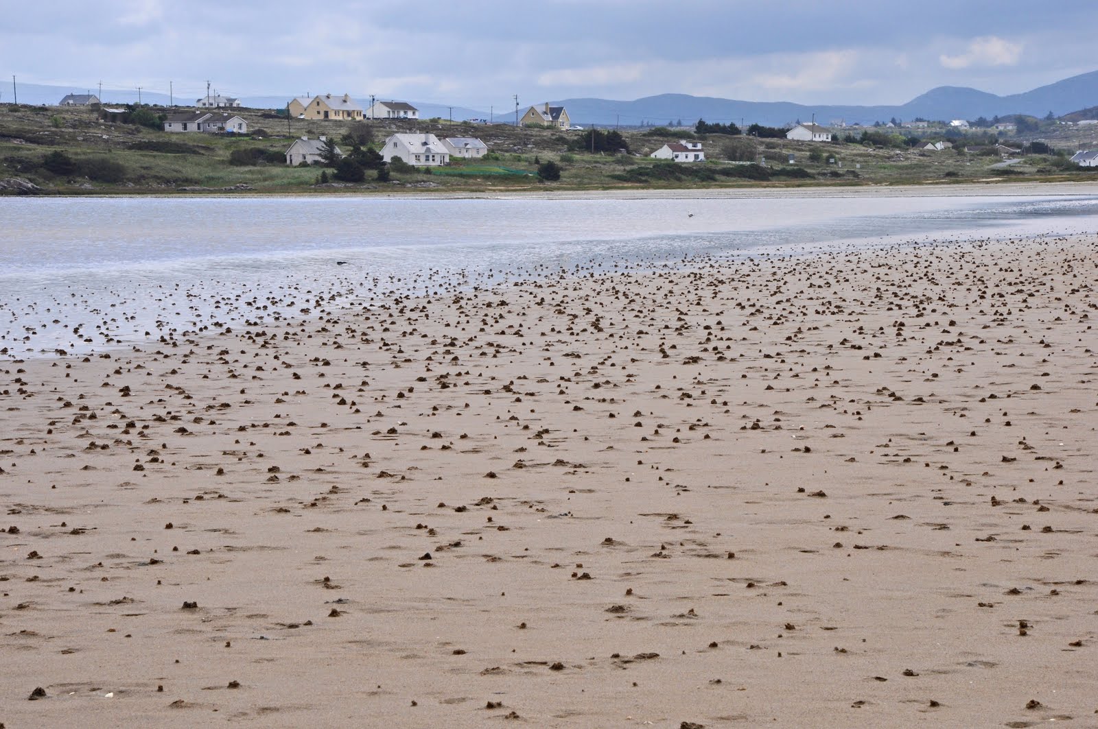
Trawmore strand, near Keel
Kildavnet Tower, Achill


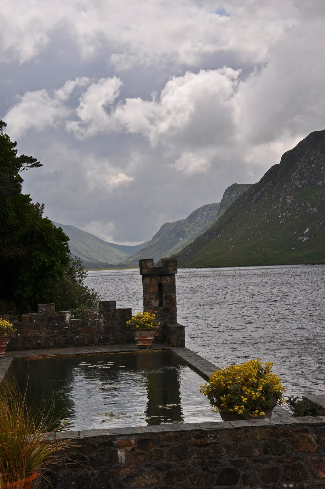
Leenane, across Killary Fijord


Horseback riding on beach, near Westport


Kildownet (Kildavnet) Church ruins, Achill Island


Kildavnet Tower House  "Grace O'Malley's Castle"

Rockfleet Tower, under repair
Clare Island, in distance
Keel

Megalithic Tomb, Achill Island


"... Here amid the gloom and the dark wind, rises a land populous in parts with cottages as a city with human beings. It is a place of tiny dwellings and tiny farms. Out in the fields you see the women labouring and bringing wonder into the rocky darkness of the island with their heavy petticoats of red and blue that you will not surpass for color in a Titian. The men dig the earth into strange shapes - furrows and ridges that you would conceive might be dug blindly by night. The social spirit is here, however, making continual war on the hungry bareness of things. The people delight in dancing and song and old men scrape a living from twittering fiddles on the earthen cottage floors in the evenings."

(from 'Home Life in Ireland', quoted in Mary Cosgove, 'Paul Henry and Achill Island', in Ullrich Kockel (Ed), 'Landscape, Heritage and Identity', pub. Liverpool University Press, 1995)


The weather is inevitable the ice breaker when you talk to someone here. Especially (as the Irish say) the last month was the worst May they could remember being quite windy and rainy. Today I was discussing the weather with a patient who said ''You have to dance with the tune that's played for you.''

I went for a day drive to Achill Island, in county Mayo, after bidding farewell to my family earlier in the day, at the bus stop. This was a scenic drive. I went north from Carna,  via Leenane, around the Killary fjord, up the  Doolough Valley route via Louisberg, around Crough Patrick, thru Westport, then along the ''Alantic Drive'' coastal route, west to Achill Island, via a bridge.

I am quite impressed with county Mayo, it is different then my county Galway, less rocky. Mostly rural, with sweeping landscapes.  Ireland impresses me that for its' size, there is so much interesting geography, then you throw in the ruins and the interesting culture...

I did not arrive to Achill until mid-afternoon, due to a late start, and multiple photo op stops on the way. Highlites included the Doolough Valley drive from Leenane to Louisberg, the beach before Westport with horseback riders, vistas of Crough Patrick and the Atlantic Drive.

Crough Patrick is  nicknamed the Reek, a 764 meters (2,507 ft) tall mountain by Irish standards, and an important site of pilgrimage.  On "Reek Sunday", the last Sunday in July every year, over 15,000 pilgrims climb it, many barefoot! Saint Patrick reputedly fasted on the summit of Croagh Patrick for forty days in the fifth century and built a church there. Popular legend says that at the end of Patrick's fast, he threw a silver bell down the side of the mountain, knocking the she-demon Corra from the sky and banishing all the snakes from Ireland.
I continues NW, stopping at a nice beach on Clew Bay, watching some horseback riders. Then, I drove via Westport north, and then west, on the Atlantic Drive, which is a coastal route to Achill Island. Good vistas of the coast and Crough Patrick. I covered the Corraun Peninsula, finally crossing a bridge to Achill Island.

Achill is the largest Irish island, with multiple blue flag beaches, and some interesting ancient sites. It is a destination for Irish campers. In the past, fishing was a significant activity but this aspect of the economy is small now. At one stage, the island was known for its shark fishing, basking shark in particular was fished for its valuable liver oil.

Granuaile, the Pirate Queen, maintained a castle at Kildownet in the 16th century. It is currently undegoing repairs. She is buried under a similar tower of hers, on Clare island.  James Joyce used the legend of Gráinne Ní Mháille ("her grace o'malice") in chapter 1 of Finnegans Wake. I also saw an ancient church and cemetery at Kildavnet. There is a monument there to the Clew Bay drowning of 1894, discussed below.

In 1894, the Westport railway line was extended to Achill Sound. The train station is now a hostel. The train provided a great service to Achill, but it also fulfilled an ancient prophecy. Brian Rua O' Cearbhain had prophesied that 'carts on iron wheels' would carry bodies into Achill on their first and last journey. In 1894, the first train on the Achill railway carried the bodies of victims of the Clew Bay Drowning. This tragedy occurred when a boat overturned in Clew Bay, drowning thirty two young people. They had been going to meet the steamer which would take them to Scotland for potato picking.
The Kirkintilloch Burning Disaster in 1937 fulfilled the second part of the prophecy, when the bodies of ten victims were carried by rail to Achill. These people had died in a fire in a 'bothy'. This term referred to the temporary accommodation provided for those who went to Scotland to pick potatoes.

Next was Keel, a picturesque coastal setting, with Trawmore strand, the best known beach on Achill, almost 2 miles long. There were mild waves, good for young surfers. People camped behind the dunes, an ideal setting. Then, I continued along the coast on a cliff top road, to Keem Bay, at the western tip of Achill. Reportedly, there is amethyseth in the cliffs around this area.

There is a famous painting by the artist Paul Henry 'Launching the Currach' set here. For Paul Henry Achill Island was love at first sight and he instantly decided to remain on the island, tearing up his return rail ticket and scattering the fragments into the sea. Henry castigated the young girls on Achill for turning up to model wearing modern silk stockings and high heeled shoes, rather than barefoot and in the everyday clothes handed down to them by their grandmothers. Paul Henry often had to sketch surreptitiously in the villages on Achill, hiding his sketchpad inside a book. There is scant reference in any of Paul Henry's works to the civil upheavals that transformed Ireland during his lifetime, nor any attempt to engage with the underlying political reasons for the harshness of life for the people of Achill Island. He chose instead to focus on a timeless struggle between man and nature - sometimes harmonious, as in the landscapes with cottages, and sometimes tragic, as in the Synge-inspired 'Waiting for the Boats'. He explained this painting: "... One morning the long Atlantic rollers were thundering on the cliffs as I came round a corner and saw a group of men and women huddled together on a promontory - they had been there all night their eyes searching the troubled waters for a sight of the fishing boats which were never to come home'. Paul Henry painted the spiritual heart of Ireland "... There are not a few artists who would despair of redeeming from sordidness a string of unkempt cabins, with turfstacks heaped against the white-washed gables, and rain-water standing in pools on the broken roadway. But in Mr Henry's hands this becomes not merely dignified but epochal, a symbol of the spirit of the West'.

After Keem, I went to the northern coast of Achill, where I walked up the slope of Slievemore to a megalithic tomb, situated with great vistas of Achill Island. There is a lot more to see on this beautiful island, but I had to leave, as it was getting dark.


Will you meet me on Clare Island
Summer stars are in the sky
We’ll get the ferry out from Roonagh
And wave all our cares goodbye
And we’ll go dancing at the ceili
We’ll go kissing on the strand
Take our clothes off in the moonlight
Skinny-dipping hand in hand
And we’ll start drinking in the twilight
Keep it up until the dawn
In both the bars
Because there’s no guards
To take our names and send us home.

First verse, Clare Island, the Saw Doctors


Friday, July 22, 2011

The Antrim Coast, Northern Ireland


Note round tower cap is intact


Tomb


Paper notes hanging in tree-offerings at Creevykeel


Sunset near Bundoran

Derryveagh Mountains, south of Glenveagh National Park


Beach, The Rosses


A whole lot of clams


Dunlewey Parish Church, Gweedore


Errigal Mountain, Gweedore

Glenveagh National Park


Glenveagh Castle


Glenveagh Gardens


Red Deer, Glenveagh National Park


Roundabout Art


Castle between Derry and Bushmills

Dunluce Castle


Bushmill's Inn (flying an American flag)


Giant's Causeway (this and about 25 more photos)


The Organ, Giant's Causeway- note person standing at bottom of columns


Dunseverick Castle ruins


View from cliffs at Dunseverick Castle


Along the Antrim Coast


Whitepark Beach


Old stone building at Whitepark Beach


Rocks, Whitepark Beach


Same stone structure, lower right

Unknown plants with 2' leafs

Carrick A Rade Rope Bridge- can you see it?


Kinbane Castle


Golf course surrounding the Bonamargy Friary (also misnamed as an Abbey)

Old Coast Guard Station, Torr Head


Scotland!


Things in Ballycastle, and other places in Ireland, run on "Irish Standard Time", according to a local, which, when translated, means "It starts when it starts."


Justine and the kids spent the last month in Pennsylvania and Michigan, with Justine's parents, and siblings. They seem to be adjusting to life back in the USA fine. Lots of swimming, shopping, and just having plain ole fun. The girls really miss Ireland, and they hope to return soon. Recently, they flew to Seattle, and they will be house jumping over the next month, as they head towards our home on Camano Island in mid-August, when I return.

 I am having a blast, working 5 days, off 2 days, madly exploring this beautiful country. Gabriel, a local fisherman, comes by the house every week, offering fresh fish, typically 4-5 types of white fish, salmon, local scallops (they are right out in front of my house!), lobsters and today's special "Sweaty Betty" a Greater Forked Beard hake. How about that!

Recently, I watched '' The Matchmaker'' a cute movie filmed in nearby Roundstone, Ireland. This is maybe my favorite town, along with Carna and Clifden. Good local scenes, and colorfull vernacular in this movie. I have been hiking the surrounding country side with my friend Sean. Also, I went for a sail in a Galway Hooker, and more boating with Gerard, in his currach.

I have fallen behind on getting some blogs published, due to the volume of cumbersome photo editing. When it is sunny, I am out and about in the evenings, rather than editing. Future blogs include: Spiddle Hooker and Currach Races, Achill Island, Waterford Tall Ships, Sailing in a Hooker, Mac Dara's Day, Irish Music (finally-some great sessions, will likely link to You Tube), more of Carna, Roundstone and yes Rome, Italy.


                                                    The Antrim Coast


I left Friday, after work, for a weekend trip to Northern Ireland, part of the United Kingdom. I live in the Republic of Ireland, a separate country, but the same island. I have been fascinated by images of  the Giant's Causeway, which is part of the Antrim Coast, an area as far north as you can go on this island. Gerard told me about this area, where he would like to go on his motorcycle sometime. It is perhaps the most beautiful coast I have seen, at least outside of Hawaii.

I drove 675 miles this weekend, one way is around 6 hours non stop. I left after work, which  meant spending the night in Donegal. I have a MP3 with over a thousand songs (NOT from Apple) connected to a small portable 20 dollar speaker box, that allows for commercial free tunes whilst driving.

 I stopped and photographed the Turlough Round Tower. From Wiki: St. Patrick founded the first church here and baptised many people at a nearby well. The Round Tower is unusually squat, and the only one I have seen that still has a cap. It was built between 900 and 1200. The church was built in the 18th century but incorporates an earlier window and a Crucifixion plaque dated 1625.

I also stopped at Creevykeel, near Ben Bulbin, which I missed on the last northerly trip. It was good to be in Yeat's backyard again. The court tomb at Creevykeel is amongst the finest examples of a full-court tomb in Ireland. Dating from the Neolithic Period, 4000-2500 BCE, the tomb was excavated in 1935 and shortly afterwards restored. The excavations uncovered four cremation burials, decorated and undecorated Neolithic pottery, flint arrow heads, polished stone axes and other artifacts, including a chalk ball.

I called the Abby Hotel in Donegal, looking for my economy priced 40 euro crash pad, where I had stayed before. When I arrived, I got a free upgrade, they said because I had been nice on the phone. The next morning, I left to do a 4 hour hike on the Slieve League cliffs, but the early rain made me again turn around. I may never get to hike the edge of these two thousand foot cliffs. I drove north to Letterkenny, spotting a five euro haircut sign on the way. After that ten minute diversion (I don't have much left on top, so it doesn't take long-if it does, then I know the stylist is messing around), I continued my journey.

There are minimal traffic lights in Ireland, roundabouts are the order of the day. They are quite efficient, once you get comfortable with them. If you get confused, you just keep circling until you see your exit. This means you better know which exit you need before you enter the roundabout, so I am always writing down the next turn in my journey, to stay a step ahead. Occasionally I have a dense moment, forgetting that you yield to traffic on the right, which makes for brakes. There is some cool roundabout art, indeed I snapped a few pics on the fly, not to be recommended to the dexterity challenged folks. I bought a basket of fresh local strawberries, which reminded me of the great Puget Sound strawberries that I was missing this summer. I am hearing the various accents of this country during my travels, and here up north, it is a classical sounding Irish accent, quite thick.

I did a loop in the Derryveagh Mountains, including the Glenveagh National Park, and also the Rosses. This is in the most northwestern part on Ireland. Glenveagh has some of the last forests in Donegal county. I assume the forests were easy money firewood, hundreds of years ago. Now the bog is the primary fuel source. A whole lot of time is spent each summer, cutting bog, drying, transporting and stacking it for fuel for the colder months. The first half of this pretty loop, I encountered zero cars. Amazing.

Glenveagh was started by Geroge Adair. He evicted 244 tenants from the area, earning an infamous reputation. His wife started the Castle gardens.  George built the Glenveagh Castle in the 1800's. It was later owned by Professor Arthur Kingsley Porter of Harvard, who disappeared mysteriously from Inishbofin Island. The last owner was Henry McIlhenny of Philadelphia. He also contributed to the gardens.

These are probably the best gardens I have ever seen. There are plants from all over the world, including Chile, Madeira and Tasmania. There was peak bloom, and many exotic flowers to photograph. I took the shuttle to the castle,in order to save time. As I got on for the return, the driver said be alert, as he had spotted 2 red deer on the last trip. This was a rare occurrence, as the deer are up high in the mountains during the summer months. There are 2 big wild red deer herds in Ireland, and one is here. Sure enough, we spotted a buck and a doe on the return trip, so I quickly snapped some photos. You can see the fuzzy new antlers. That was cool, as now I have seen deer and foxes in Ireland, beginning to feel like a local.

I also drove an ocean front circle called the Rosses. Not very exciting, but I did go for a nice beach walk. Next, to Northern Ireland. I drove via Derry, the  walled city. It is one of the largest cities, and the site of Bloody Sunday,  where immortalized in the song by U2, also two of the Beatles wrote songs about this event, an incident in 1972.   Twenty-six unarmed civil rights protesters and bystanders were shot by soldiers of the British Army. Bloody Sunday remains among the most significant events in the Troubles of Northern Ireland. There are still conflicts, I even heard some on the BBC while I was travelling, minor riots, something to do with the Ulster flag not getting enough respect.

I arrived at Bushmills, the town named after the whiskey. The Distillary is the oldest in the world 1603, and I do like their whiskey. I had four star accommodations, at the Bushmills Inn. Nice place. I headed off to the nearby Giant's Causeway. On the way, I stopped off at Dunluce Castle, perched on the edge of the ocean. It had closed 2 min before my arrival, but I got some great exterior photos.

Dunluce Castle (from Irish: Dún Libhse) is a now-ruined 1300's  medieval castle in Northern Ireland. It is located on the edge of a basalt outcropping in County Antrim , and is accessible via a bridge connecting it to the mainland. The castle is surrounded by extremely steep drops on either side, which may have been an important factor to the early Christians and Vikings who were drawn to this place where an early Irish fort once stood. the Girona, a galleass from the Spanish Armada was wrecked in a storm on the rocks nearby. The cannon from the ship were installed in the gatehouses and the rest of the cargo sold, the funds being used to restore the castle. MacDonnell's granddaughter Rose was born in the castle in 1613.

At one point, part of the kitchen next to the cliff face collapsed into the sea, after which the wife of the owner refused to live in the castle any longer. According to a legend, when the kitchen fell into the sea only a kitchen boy survived, as he was sitting in the corner of the kitchen which did not collapse. In 1973 the castle appeared on the inner gate fold of  Led Zeppelin album Houses of the Holy. It is one of the most photogenic castles that I have seen, due to the setting.

The Giant's Causeway is an area of about 40,000 interlocking basalt columns, the result of an ancient volcanic eruption.The tops of the columns form stepping stones that lead from the cliff foot and disappear under the sea. Most of the columns are hexagonal, although there are also some with four, five, seven and eight sides. The tallest are thirty nine feet high. Similar sites include the flood basalts of the Columbia Plateau of eastern Washington state, which I will have to see.

I had waited for this moment for months, I savored the site, with fantastic weather, I watched the color of the rocks transform as the sun went down. What a great start of my trip to the Antrim Coast. Then, I enjoyed my fancy evening at Bushmills, got a good night's sleep, and then headed down the coast.

I saw the remains of the Dunseverick Castle, most of which fell into the sea, just recently in 1978.  Saint Patrick is recorded as having visited Dunseverick castle in the 5th century AD, where he baptized Olcan, a local man who later became a Bishop of Ireland. The original stone fort that occupied the position was attacked by Viking raiders in 870 AD.The castle was occupied by various Irish chiefs and lords until its capture and destruction by  Cromwellian troops in the 1650s, and today only the ruins of the gate lodge remain. A small residential tower survived until 1978 when it eventually surrendered to the sea below. What a loss. It was a 'key' ancient site in Ireland. One of the royal roads from Tara, seat of the Kings of Ireland ended at Dunseverick castle. I walked from the parking area down to the sea, then up to the remnants. Another great location- there were wildflowers everywhere, nesting birds in the cliffs, great vistas, and I could even see fish swimming in the crystal clear aqua green sea, hundreds of feet below!

I can't get over the wild fuchsias that line the roads every where in Ireland. Next, I went to Whitepark Bay. This is a beautiful beach, which has been designated an area of Scientific Interest due to its flora and fauna. Rare wild orchids can be found around the locality,  the geology is wonderful - Jurassic clays, volcanic rock, limestone and flint deposits, fossilized shellfish and ammonites to find along the beach. I am not a geologist, but I found the rocks fascinating. Not sure if I saw fossils. Just above the beach is a house for sale. Tempting...

Next was Ballintoy Harbor, and Carrick-A-Ride Rope Bridge. I had wanted to walk across the rope bridge, suspended seventy five feet above the water between the mainland and an island, but it was a bit crowded. I did find a nice vantage point further down the coast, spying the bridge and snapping a few pictures. Also, I had good views of Rathlin island, accessible by ferry, home for a quarter million birds.

Next was the Kinbane Castle at another stunning location, on a long, narrow limestone headland projecting into the sea  I descended about a thousand feet on steps then across a flowered field, then up the headland to the ruins. This is a two storey castle  built in 1547 by Colla MacDonnell,  layed siege in 1555 by English forces, the castle was partly destroyed by cannon fire. Rebuilt afterwards, Colla MacDonnell died at the castle in 1558.

The hollow below the castle known as Lag na Sassenach (Hollow of the English) and it was allegedly during the 16th century that a garrison of English soldiers laying siege to the castle were surrounded and massacred. Fires were lit on the headland as calls for assistance were answered by clansmen who came from all directions and surrounded the garrison. There is an abandoned structure there called the salmon house, where presumably salmon was hoisted up from boats below and transferred to land transit.

This coast is quite hilly, I was often in 2nd and even in 1st gear. Typical narrow roads, where opposing cars (usually) slow to 5 mph to make sure the mirrors don't collide. There is not a car in Ireland with out scratches on the left side of the car, due to hitting brush, as there are no shoulders on most roads-sometimes rock walls.

I drove thru Ballycastle to the adjacent Bonamargy Friary ruins. I saw tombs dated in the 1700's with the English style headstones, spooky looking, vs. the Celtic crosses that I have become familiar with. Many tombstones were leaning at odd angles, which adds to the creepy factor. The Friary is surrounded by a golf course so I watched for errant balls. I suppose that location helps preserve the ruins. I saw a par three hole called the Abbey. The Friary is a late Franciscan foundation established in 1485 by Rory MacQuillan. It is said that the first battle between the warring MacDonnell (see Kinbane Castle, above) and MacQuillan clans was fought on nearby land. At the main entrance to the friary is a small, two storey gatehouse which opens into a store and workroom. Well worn steps lead directly to the dormitory above. Traces of an altar can still be found in the adjoining church, and the locked vaults (see photo with green door) hold the remains of the celebrated chieftain, Sorley Boy MacDonnell, and several of the earls of Antrimthe.

 The Friary’s most famous resident was the 17th century prophet and recluse Julie MacQuillen. Known as ‘The Black Nun’, MacQuillen wished to be buried at the entrance of the chapel so that she might be trodden under the feet of those who entered. The Friary is supposedly haunted by this Ghost of the Black Nun, who lived there alone after the Friary fell out of use in 1641. There is a common story that the Black Nun was murdered on the steps leading to the upper floor of the Friary. Legend has it that she fell on the thirteenth step and that bad luck will befall anyone who walks there.

Good vistas were had from Torr Head, where there is an abandoned coast guard station that I hiked up to. Scotland is visible from this vantage point.

Finally, I made it to Cushendun and subsequently Cushendall. These are picturesque, quaint coastal towns. Cushendun was designed  in the style of a Cornish village, with a line of pretty houses on the coast. The town lies at the foot of Glendun, one of the nine Glens (mountains) of Antrim county. There are some beautiful loop drives thru the Glens, nearby. 

Cushendall has a Curfew Tower. This tower in the centre of the village was built by then landlord of the town, Francis Turnley, in 1817, to confine riotous prisoners. An army pensioner was given the job of permanent garrison and was armed with one musket, a bayonet, a brace of pistols and a thirteen-feet-long pike.This part of the Irish coastline is separated from Scotland by the North Channel,  16 miles away. I had hoped to go to Scotland whilst in Ireland, to no avail.

It was a 7 hour drive down the Anterim Coast, which took only forty-five minutes on return, as I went a bit inland. I highly recommend taking every coastal side road on your trip, or you will miss many of the highlights. I would recommend a more leisurely 2-3 days for this drive. I beelined back to Carna,  I listening to the live Oxygen concert happening in Ireland on the drive.  Coldplay sang some of their classics, with me and the audience singing along, as I watched the moon rise over Galway Bay.


Well it was Sunday bloody Sunday
When they shot the people there
The cries of thirteen martyrs
Filled the Free Derry air
Is there any one amongst you
Dare to blame it on the kids?
Not a soldier boy was bleeding
When they nailed the coffin lids!
—John Lennon  "Sunday Bloody Sunday"