 |
| Quinn Friary |
 |
| Craggaunowen Castle |
 |
| Living quarters, Craggaunowen Castle |
 |
| Occupant (staged) Craggen.... |
 |
| Remnants of 2,500 year old dugout canoe |
 |
| Crannogs in Round Fort |
 |
| Crannog construct |
 |
| Interior, Crannog |
 |
| Boat made of animal skins |
 |
| Primitive straw bed |
 |
| Ceiling, Crannog |
 |
| Another Crannog |
 |
| Crannog near Carna, that Sean and I walked to |
 |
| Use control + to enlarge print |
 |
| The Brendan Boat |
 |
| The Brendan Boat, sailing across the Atlantic |
 |
| Tower Castle, Clare County |
 |
| Adare Castle |
 |
| Adare Church |
 |
| Thatched roof houses, Adare |
 |
| Dingle Peninsula |
 |
| Heading towards Conner Pass, looking back at Dingle Peninsula coast |
 |
| After Conner Pass, town of Dingle to the right, Iveragh Peninsula in distance |
 |
| Skellig Rocks in distance |
 |
| Dingle |
|
Dingle, in distance: Inveragh Penninsula, Skellig Rocks |
 |
| Moon and sunset, Inveragh Peninsula |
 |
| Sunset, Dingle Peninsula |
 |
| Houses on Iveragh Peninsula |
 |
| Ballycarbery Castle, Cahersiveen |
 |
| Cahergall Ring Fort |
 |
| Squall to right, Ballycarbery Castle to left |
 |
| Walking the parameter of Cahergal Ring Fort |
 |
| Greg at Cahergal |

 |
| Colored beach rocks, near Portmagee |
 |
| Currach |
 |
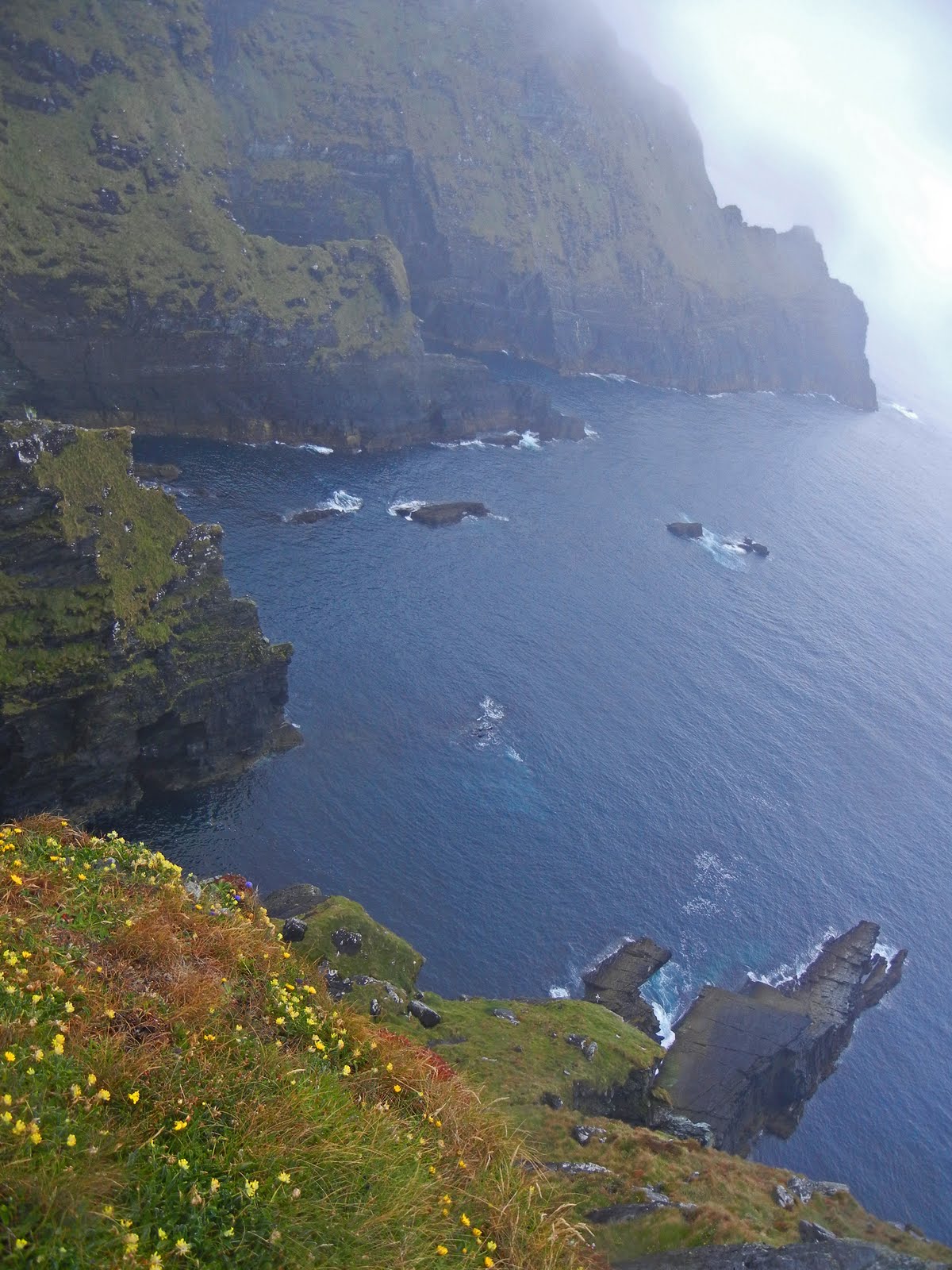
| Cliffs, near Ballinskelligs, Inveragh Peninsula |
 |
| Surfing Beach |
 |
| Charlie Chaplin statue, Waterville |
 |
| Ogham Stone (writing worn off) |
 |
| Staigue Ring Fort |
Kil
 |
| Killarney National Park |
 |
| Wild Rhododendrons |
 |
| Ross Castle, Killarney |
I went for a (all to classic) mad dash to the SW part of Ireland- covering 600 miles in 2 days...
Saturday was great-sunny and perfect for driving down thru the country and circling the Dingle Peninsula. Sunday was rainy and overcast, sullying my planned boat trip to the Skellig rocks and instead the drive around the Inveragh Peninsula (Ring of Kerry), the latter of which I did anyway. I plan to go back and repeat that portion of the trip in better weather. I did see a good bunch of ancient sites, that can be visited regardless of the atmospheric conditions.
I drove south from Carna, with my first stop in Ennis, a small, pretty city, with narrow streets and pastel colored shops. My next stop was the Quinn Abbey, built in 1402. The ruins are impressive, and fairly well preserved. I met a nice Irish chap, Joe, who chewed me out for taking photos from the surrounding grounds (no signs!) and reminded me that any Abbey photos that I took could not be sold (Irish property!) then became friendly, giving me a lot of information about the Abbey-it is actually a Friary. Before this, it was a monastery, then a Norman Castle, then a church. In about 1640 the building became a college and is alleged to have had 800 students. Oliver Cromwell arrived only 10 years later, murdering the monks and destroying the abbey. In 1671 the abbey was once again restored, but never regained its former status. Eventually in 1760 the monks were expelled, although the last Friar remained there until his death in 1820, by which time the buildings were ruined by neglect. I always fantasize about the events that occurred between the walls of ruins like this, centuries before.
Then I visited Craggaunowenn near Quinn. This is an area with restored and recreated ancient dwelling houses and other features of everyday life during the Pre-historic and early Christian Eras. I will quote extensively from the brochure there. The existing castle from 1550 was restored. It is a Tower House type of Castle. It was neat to actually enter it, and visit the different levels (via spiral staircase) where the occupants lived. It seemed almost romantic, with the cozy rooms, and vistas from the windows. There was a woman there, spinning wool.
Next I saw a Crannog. This is a dwelling built typically Interestingly, there are Crannogs near Carna, and literally 4 days earlier, Sean took me for a walk, where we saw one, in the middle of a small local lake. Dr. Hooke told me how the ancient occupants accessed it, by knowing where the underwater stepping stones were located. One false step by a stranger, and you would be swimming! Also, dug out canoes and bridges were sometimes used for access.
The Crannog was first used almost three thousand or so years ago. They were made by placing stones, and wood, etc, on the lake bed, making a platform, covered with dirt. The house sat on this, built of wattles and mud, with a thatched roof. The reconstructed house I saw looked watertight, with a thick layer of thatch as the roof. There was a lot of room, with straw beds, fur pelts, and even a small boat, made or fir skins. There was also a dug out canoe, that had been excavated.
There was a reconstructed ring fort, and I saw real ones later this weekend. They are incredible structures, used as farmsteads around Ireland, from the 5th Century onwards. They have circular stone walls, with scattered huts and a central fire. This one had a reconstructed hand lathe machine. Once comment about wood. Some of the blog readers have commented on how rocky this country is. Certainly without many forests, the glacial rock base of this land is most evident. I have noticed that Ireland does not have many forests. Since wood was the easiest fire fuel, the forests were used up many years ago. There were relatively recent government grants to re forest areas.
The Brendan exhibit was another stunning highlight. The monk St. Brendon the Navigator, who died in 583 A.D., was, according to a ninth century manuscript, the first man to discover the 'Promised Land' across the Atlantic, which is thought to be America. This would have been almost one thousand years before Christopher Colombus. In 1976, British explorer Tim Severin built a leather hulled boat, stitching together forty-nine ox hides, stretching them over a wooden oak frame, based on the vessel described in the manuscript and on the currachs still used on Ireland's west coast. He used the 'Stepping Stone Route' across the North Atlantic, setting sail from the West coast of Ireland, over wintering in Iceland, ultimately reaching the shores of Newfoundland. The leather hull was thought to better handle the crushing ice flows, than a wooden hull. When the hull was punctured, the crew would sew a leather patch over the hole! One member holding the patch on the inside, and the other holding the patch on the outside.
Joe from the Friary convinced me to go a different route to Dingle, so on this trip I missed some of the best west coast, south of the Cliffs of Moher. I went via Limerick, and thru Adare, where I photographed the Adare Castle, a medieval castle on the River Maigue. Also, there were fine examples of thatched roof houses in the town.
There are three major peninsula on the south and southwest part on this country, jutting out like fingers into the Atlantic ocean. If you are on one, there are good views of the adjacent one.
I went counter clockwise on the Dingle Peninsula. There are some great beaches labeled of ''blue flag'' quality, which I did not visit, due to time constraints. I went inland, over Conner Pass, enjoying excellent views of the mountains and lakes. After the pass, you descend towards the town of Dingle, and you can see the Inveragh Peninsula across Dingle bay, with Skellig Rocks off the tip. As mentioned, my boat trip to this World Heritage Site was cancelled, due to inclimate weather the following day. I hope to return, getting to the island by boat, then to climb the ancient stairs and see the monastic bee hive dwellings there.
I passed thru the town of Dingle, and headed to the Gallarus Oratory. I saw a lot of Irish students, walking in groups on the rural roads. What an idyllic area to learn Irish. There are areas like this around the country (including Carna) where these youth go for 3 week intensive Irish language sessions. They go to school, and live with the locals, in their houses. If they speak any English then they are sent home. There is a continuing government supported initiative to support the teachings of the endangered Irish language, which is threatened with changing customs.
The Gallarus Oratory was made to stand the test of time, and the wild buffeting gales on the Peninsula. It is a small, early Christian church, constructed around 800 A.D., of dry rubble masonry, using local grit stone. The roof is formed by the gradual rise of the side walls from the base upwards. Ingenious. It is still waterproof, 1,300 years later. According to local legend, if a person climbs out of the oratory via the window, their soul will be cleansed. Successive invaders, the Vikings and the Normans, burned, robbed and destroyed the settlements around Gallarus, but the Oratory has survived intact.
I arrived on the Ivragh Peninsula around sunset, which is quite late now in June-it doesn't get very dark until after 11 PM. I stayed at a cozy hotel in Glenbeigh, then beat the tour buses, with an early morning start. The weather was poor, so I concentrated on seeing various ancient ruins, as the coast was fairly obscured by clouds. Near the town of Cahersiveen, there are two important sites.
The Ballycarbery Castle was constructed in the sixteenth century. The castle is said to be the tenth wonder in Ireland. It is on a lovely setting. In 1652 it was attacked by cannon-fire from parliament forces. The castle was surrounded by a high wall with less than half still remaining. There are
arrow slits dotted along the bottom of the remaining wall. More from Wiki: Ballycarbery Castle has been featured in the 2010 film Leap Year. Anna Brady plans to travel to Dublin, Ireland to propose to her boyfriend Jeremy on February 29,
leap day, because, according to Irish tradition, a man who receives a marriage proposal on a leap day must accept it. In the movie the character of Anna Brady asks Declan "So, what's the story with this place?" (the Ballycarberry Castle) He replies, "Hundreds of years ago, there was this beautiful girl called Grainne. She was promised in marriage to marry this fella called Fionn. He was kind of a cranky old warlord old enough to be her grandfather. And therefore, she wasn't in love with him. On the night of their betrothal, whom did she meet but a handsome young warrior--Diarmuid. They fell madly in love at first sight. But well, what could she do? She slips a sleeping potion in everyone's drinks and the pair of them run off together across the Shannon. Fionn wakes, and there's Grainne gone. Well, he goes mental. Takes his army and heads off in hot pursuit. But it was the people, you know, the people in the villages of Ireland--they took pity on Diarmuld and Grainne. They hid them in forests and in their barns and castles where they'd sleep one night and then they'd move on. Sleep was all they did. 'Cause Diarmuid, good man that he was suffering the old guilt about two timing Fionn and out of respect for him didn't take it any further. And then they came to this castle...and this view. And its said, you know, that unable to resist such beauty that is here...in this place, they consummated their love."
Less then a mile away was another home run, the Cahergal Ring Fort. This Fort is believed by archaeologists to have been built between the 9th and 11th centuries and it is another amazing feat of ’dry wall’ construction with a ten foot thick fort wall. The fort’s interior wall is stepped with many terraces or inbuilt stairs which can be climbed allowing you to walk along its wide girth and enjoy a wonderful view. There are no safety railings here! Fortunately, there was no wind today. Within the fort, is the remains of a lone beehive hut. A nice British coupe, driving around Eire in a rented motor home, took a photo of me, with my camera.
I did not go to Vanencia Island , due to time constraints. The highlight there, which I hope to see on a future trip, are tetrapod tracks. In 1993 an undergraduate geology student discovered a tetrapod track here. The tetrapod tracks are footprints of a animal believed to have been created some 350 million years ago. The Valentia island track way is of international importance as it provides some of the oldest evidence of one of the first water dwelling creatures which crawled out of the water and made the important evolutionary step toward land dwelling.
I continued via Portmagee, saw a small, off the beaten track beach, with some bluish and purple flat rocks and then got lost on a drive called the Skellig Circle. Nice views of the countryside. I also stopped where there were good views of the coast, this day partially obscured by the fog and clouds. I saw some nesting shorebirds, in the cliffs. Then I stopped for a seafood chowder lunch in Waterville, which claims a famous inhabitant, Charlie Chaplin, the comic actor who lifted people’s spirits after the first World War and the Great Depression. The actor – whose motto was “life is a tragedy when seen in close-up, but a comedy in a long shot” – loved the seaside fishing village and spent every summer with his family there for almost 40 years. There is a comedy film festival here this August, which Charlie Chaplin's daughter hopes will become an annual international event.
I continued my anti-clockwise parameter drive of the Ring, driving thru Caherdaniel, named after and the home of Daniel O'Connell The Liberator (1775-1847). He campaigned for Catholic Emancipation—the right for Catholics to sit in the Westminster Parliament, denied for over 100 years—and repeal of the Act of Union which combined Great Britain and Ireland. During his education and studies of Irish history, he concluded that "in Ireland the whole policy of the Government was to repress the people and to maintain the ascendancy of a privileged and corrupt minority." He was in a dual, staged before a packed house at the Dublin Castle, mortally wounding the other man but sympathetic to the widow and daughter, paying regular monies to them for 30 years, until his death. Ironically, considering O'Connell's dedication to peaceful methods of political agitation, his greatest political achievement ushered in a period of violence in Ireland. O'Connell's philosophy and career have inspired leaders all over the world, including Mahatma Gandhi and Martin Luther King.
Nearby, is an Ogham stone. This stone was the earliest system of writing to appear in Ireland, a unique language, with some Roman alphabet foundation. There are two main schools of thought among scholars as to the motivation for the creation of Ogham. Scholars have suggested that Ogham was first created as a cryptic alphabet, designed by the Irish so as not to be understood by those with a knowledge of the Latin alphabet. With this school of thought, it is asserted that the alphabet was created by Irish scholars or druids for political, military or religious reasons to provide a secret means of communication in opposition to the authorities of Roman Britain. The second main school of thought, is that Ogham was invented by the first Christian communities in early Ireland, out of a desire to have a unique alphabet for writing short messages and inscriptions in the Irish language.
Next, I visited the Staigue Ring Fort, thought to have been built during the late
Iron Age, probably somewhere between 300 and 400 AD, as a defensive stronghold for a local lord or king. I got soaked during a downpour there.
Finally, I left the Iveragh Peninsula, via the beautiful Killarney National Park. There were lots of wild rhododendrons, but poor views, due to the clouds. The town of Killarney has Ross Castle, built in the 1400's, on Lough Leane. It was is the ancestral home of the O'Donoghue clan. There is a legend that O’Donoghue leaped or was sucked out of the window of the grand chamber at the top of the castle and disappeared into the waters of the lake along with his horse, his table and his library. It is said that O’Donoghue now lives in a great palace at the bottom of the lake where he keeps a close eye on everything that he sees.
The castle was amongst the last to surrender to
Oliver Cromwell's Roundheads (some of the
Puritans who wore their hair closely cropped round the head, and there was thus an obvious contrast between them and the men of
courtly fashion with their long
ringlets during the
Irish Confederate Wars), and was only taken when artillery was brought in by boat. I saw lots of fly fisherman bringing in their evening catch of trout.
Certainly my trip to the Dingle and Inveragh Peninsulas was quick, but I learned a lot, enjoying seeing some of southern Ireland, and I will be back there soon.


No comments:
Post a Comment